Devastating Beauty explores the impact that the expansion of Roman power had on the natural world and human health through a millennium. By most measures, the greatest impact is to be seen as Rome’s empire reached its fullest extent, between c. 100 BCE and CE 100. By the end of that period, the city of Rome had existed for eight centuries. The growth of the city had a profound effect on landscape. Among the most obvious and striking changes was the reduction or disappearance of several of Rome’s seven hills, so that today only the Capitoline and Palatine stand out as isolated, squared-off hills.
The city of Rome is located in the valley of the Tiber River, the longest and most important river in central Italy. The Tiber Valley has been occupied continuously for at least 5,000 years, and the earliest settlement may have been 14,000 years ago. The site of Rome itself, in the region known as Latium, was spread across seven hills overlooking the Tiber, around 19 miles (30km) inland from where the river reaches the Tyrrhenian Sea, was settled in the middle of the second millennium BC, although it was not then a city.[1]
A thousand years later, a significant city existed (up to 500 acres), with a wall surrounding that served as a basic defence and marked its boundary. Outside the wall were several large cemeteries. The construction of the city required large-scale changes to the landscape, which was prone to flooding. Archaeologists have identified quarrying, reclamation of land, and the construction of terraces to accommodate building work. A portion of the valley that was drained between the Palatine and Capitoline hills became the Forum Romanum, the Roman Forum, the heart of the ancient city. On top of the Capitoline, a temple was built to Jupiter Feretrius, Rome’s first patron god. Votive offerings, gifts for the god have been found there that date to around 750 BCE, appearing to support Varro’s preferred date for the city’s foundation, 753 BCE (or that of Dionysius of Halicarnassus, 751 BCE). Just to the east, a small plain beside the river, surrounded by three hills, accommodated a port and market. It became known as the Forum Boarium, named for the cattle traded there.[2]
The natural landscape of the river valley and its tendency to flood are integral to the city of Rome’s foundation myths, as collected and retold in prose and poetry by Virgil, Livy, and Dionysius, all writing in the first century BCE. None of these writers, of course, was truly aware of the astounding alterations the landscape of the city had undergone from its foundation to the time they wrote.
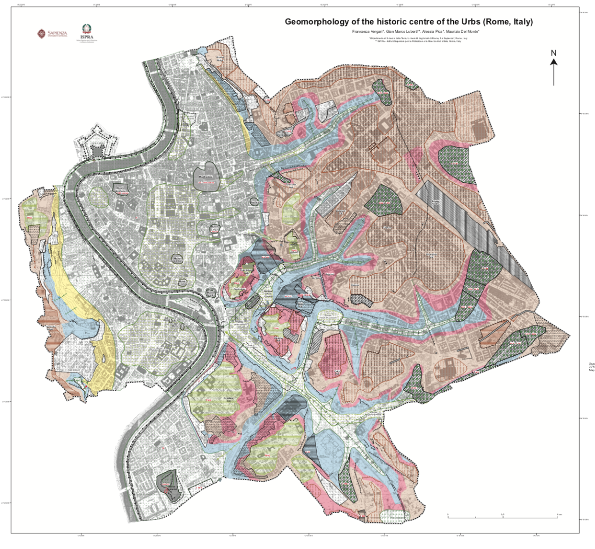
The seven hills of Rome would have been obvious in the eighth century BCE, but far less so by 100 CE. Deep valleys carved by the Tiber through the region’s pyroclastic rock were partially or completely filled in by human activity. Other valleys were deepend by the quarrying of that rock for construction. There was a very great deal of planned destruction and accompanying construction, which accelerated even after 100 CE. The Velia, a ridge that ran between the Esquiline and Palatine hills, was progressively reduced between the first and fourth centuries CE. The job was finished in the twentieth century. Perhaps the greatest movement of materials took place with the construction of the Aurelian walls in the later third century.[3]
Almost as significant as the planned movement of materials was the incidental accumulation over time of ‘anthropogenic deposits’. These are up to 20 metres deep in valleys (and 23.5 metres where Rome’s Termini railway station now sits). Ancient deposits this deep are found only within the Aurelian walls, with deposits only 2-5 metres outside. However, it is outside the walls that modern deposits, mainly since set down 1873, can be up to 16 metres deep in fluvial valleys. These figures are strikingly greater than in other historical cities. For example, in Pisa and Padua the maximum thickness of anthropogenic deposits is 6-7 metres, and in London (beside the river Thames) ‘anthrostrata’ are rarely more than 3 metres deep.[4]
Clearly, in the construction of the city of Rome, humans became geomorphic agents on a scale hardly matched in history.[5]
[1] Andrea L. Brock, ‘Floodplain occupation and landscape modification in early Rome’, Quaternary International 460 (2017), 167-74.
[2] Mary T. Boatwright, Daniel J. Gargola, and Richard J. A. Talbert, Rome: From Village to Empire (Oxford and New York: Oxford University Press, 2012), 32-7; Kathryn Lomas, The Rise of Rome: From the Iron Age to the Punic Wars (London: Profile, 2017), 35-53.
[3] Francesca Vergari et al., ‘Geomorphology of the historic centre of the Urbs (Rome, Italy)’, Journal of Maps 17/iv (2021), 6-17.
[4] Gian Marco Lubertio et al., ‘Estimation of thickness of anthropogenic deposits in historical urban centres: An interdisciplinary methodology applied to Rome’, The Holocene 29/i (2019), 158-72.
[5] R. LeB. Hooke, ‘On the history of humans as geomorphic agents’, Geology 28/ix (2000), 843-6. Cf. Nawa Sugiyama et al., ‘Humans as geomorphic agents: Lidar detection of the past, present and future of the Teotihuacan Valley, Mexico’, Plos One September 20, 20201, 21 pages: https://doi.org/10.1371/journal.pone.0257550